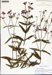
| Verbatim Directions to Locality: | along roadside in woods by Baker Landing Rd, ca. 0.5 mi drive from the Choctawatchee River (E of Rte 179A, NNW of Westville) |
| Latitude - degree with decimals: | 30.89178 |
| Latitude Direction Flag: | N |
| Longitude - degree with decimals: | 85.89075 |
| Longitude Direction Flag: | W |
| Habitat: | along roadside in mesic pine-oak woods by road |
| Local Abundance Observations: | frequent |
| Notes: | Loran C. Anderson - first county record for the Atlas
|
| Non digital information?: | N |
