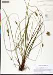
| Special Geographical Unit: | Falling Waters State Park |
| Verbatim Directions to Locality: | open powerline corridor along boundary just NE of campground at Falling Waters State Park, ca 3 mi S of Chipley |
| Latitude - degree with decimals: | 30.73154 |
| Latitude Direction Flag: | N |
| Longitude - degree with decimals: | 85.52966 |
| Longitude Direction Flag: | W |
| Habitat: | with Rhynchospora and Paspalum in drying loamy sand of open powerline corridor along boundary |
| Local Abundance Observations: | frequent |
| Non digital information?: | N |
