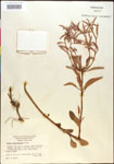
| Special Geographical Unit: | Ocala National Forest |
| Verbatim Directions to Locality: | dry sandy roadside, Ocala National Forest, 100 yds. s. of Fla. 316, 4 mi. e. of Ochlawaha River. |
| Township: | 13S |
| Range: | 25E |
| Section: | 17 |
| Habitat: | dry sandy roadside. |
| Local Abundance Observations: | common. |
| Type of Donor: | Herbarium |
| Donor: | Herbarium of the University of Florida Agricultural Experiment Station |
| Non digital information?: | Y |