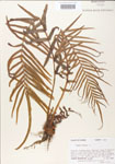
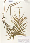
| Verbatim Directions to Locality: | in hardened sand of cliffs bordering Gulf County Canal; at end of logging road ca. 4.5 air mi NNE of junction hiways 98 and 71 in Port St. Joe. |
| Township: | 7S |
| Range: | 10W |
| Section: | 17 |
| Sixteenth: | SE |
| Quarter: | NW |
| Habitat: | hardened sand of cliffs bordering Gulf County Canal (many shells present may provide lime). |
| Plant Morphology Observations: | forming large cespitose clumps. |
| Local Abundance Observations: | frequent. |
| Non digital information?: | N |
