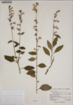
| Verbatim Directions to Locality: | S. side of Chipola River, W. of SR 71 bridge. |
| Latitude - degree with decimals: | 30.28875 |
| Latitude Direction Flag: | N |
| Longitude - degree with decimals: | 85.1446 |
| Longitude Direction Flag: | W |
| Habitat: | Disturbed floodplain forest field. |
| Plant Morphology Observations: | Erect herb to 43 cm. Floral tube very light blue. Calyx lobes w/callosities. |
| Local Abundance Observations: | Locally OCcasional |
| Non digital information?: | N |
